Explore twin villages of Muston and Hunmanby


Enjoy this pleasant and historically interesting route of about 4.25 miles. The twin villages of Muston and Hunmanby feature and these are linked by the Centenary Way, passing North Moor Farm as it crosses The Downs area.
Access to Muston village is by taking the A165 as far as a garage and pet supplies centre. Turn off as indicated: Muston ¼ mile and Malton 25 miles.
Advertisement
Hide AdAdvertisement
Hide AdStart. This walk starts from Muston village, nearly two miles inland from Filey. It’s perhaps best known for its annual summer scarecrow exhibition which attracts thousands of visitors. First mentioned in the Domesday Book as Munstone, it has been connected with its neighbouring village of Hunmanby through most of its recorded history.
Upon entering Muston, park as convenient, and continue down King Street beside white and colour-tinted cottages. Mount View provides a grassy island with seating. On the corner of the bend, the Cross Keys Inn once served the public, but ceased its service many years ago.
The School House is to your left before the road bridge spans the river. Muston is situated at the foot of the Wolds where the River Hertford wanders to join the River Derwent before entering the River Humber.
Over the bridge stands All Saints Church, which retains a font dating back to the 12th century. Continue along King Street onto West Street, to the only remaining inn – The Ship Inn. Here, turn left into Hunmanby Street, and you’ll notice a medieval cross at the road junction.
Advertisement
Hide AdAdvertisement
Hide AdCottages dated 1736 are to your left, and you’ll observe the old Methodist Church as you proceed.
Your footpath crosses to the opposite verge and winds up the steep hill known as Heatherstay, or Heathersta. This was a place of rest for the pall-bearers of bygone days. Burials had to take place in Hunmanby until Muston had its own graveyard in 1928!
On the hilltop is an electric sub-station. To the left horizon there used to be a windmill. The first miller recorded was in 1341 and the last was in 1913. Shortly, you meet a road junction, and turn left into the village of Hunmanby. The name is Danish. In the Domesday Book it appears as Hundemanebi, said to be the Farmstead of the Houndsmen. During early times wolves roamed the Wolds, and hounds may have been kept here for hunting.
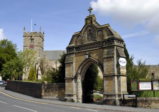
Descending Castle Hill, the Parish Church of All Saints is prominently sited on elevated ground. Admiral’s Arch was erected to the memory of Admiral Mitford.
Advertisement
Hide AdAdvertisement
Hide AdLinger in the market place in an atmosphere of by-gone days, admiring old houses and cottages. Osgodby House and Denmark House bear crests which denote former estate ownership. The White Swan Inn was a well-known hostelry in coaching days. Today alas, there is a growing concern regarding its future. The market place once bustled with activity, and market fairs were held annually on May 6 and October 29. See the market cross near the war memorial, behind which is the Methodist Church.
Unless you wish to shop in Bridlington Street, turn left between rounded pillars (beside Admiral Arch), and Church Walk leads peacefully alongside Wrangham House, which used to be the old vicarage before becoming Wrangham House Hotel.
At the far end enter Stone-gate, turning right to admire a row of chalk cottages typical of old Hunmanby. Below was a library built opposite Hunmanby Community Centre (ie the former County Primary School built in 1905). What changes do you see?
Beyond Bowling Green Lane, one reaches the Horseshoe Inn that was once a blacksmith’s shop. Can you find Elm Tree House? It was a day school in the 19th century run by Misses Bryan.
Advertisement
Hide AdAdvertisement
Hide AdReaching the road junction with Sheepdyke Lane (ie to Hunmanby Gap), allow time to see the pinfold built of seashore cobbles, on Pinfold Green. Here would be impounded straying cattle etc. The adjacent lock-up dated 1834 - the Black Hole, contained disorderly men and women!
Turning left along Outgaits Lane, continue to its farthest end, where it sweeps left into Northgate. Here, leave the lane and turn right as indicated: ‘Centenary Way’.
The metalled surface provides pleasant walking for about a quarter of a mile towards North Moor Farm. Then with the farm boundary to your left, continue along a distinct path through a series of fields, keeping beside the right hedge-line.
Meeting the road at the busy junction of the A165 and A1039, turn left towards the pet supplies centre. Here, turn left as signed Muston ¼ mile and Malton 25 miles to return to your departure point.
Distance: 4.25 miles approximately, allow 2 hours.
Advertisement
Hide AdAdvertisement
Hide AdRefreshment: The Ship Inn at Muston. In Hunmanby you’ll find inns, cafes and shops etc.
Driving and Rambling On
Maureen Robinson has published a booklet of walks. Copies priced £3.30 are available from Crag and Moor, 38 Victoria Road (until October 31 only). Or send an A5 stamped addressed envelope, plus cheque for £3.30 payable to Mrs E.M. Robinson to 14 Malvern Crescent, Scarborough.