WEATHER: Met Office issue yellow warning of snow and ice for North Yorkshire
and live on Freeview channel 276
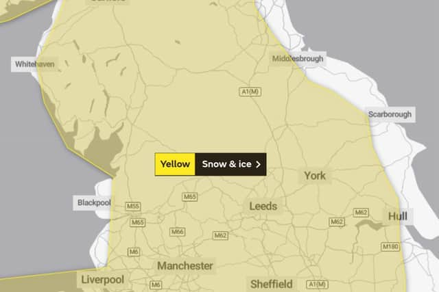
A yellow Met Office weather warning is in place tonight and tomorrow for much of the UK and North Yorkshire.
The warning comes into force at 22:00 today and remains in place until 23:59 tomorrow (Tuesday February 2).
The warning reads:

Advertisement
Hide AdAdvertisement
Hide Ad"A band of rain, locally heavy in places, is likely to push slowly northeast across parts of the UK.
"As this rain comes into contact with cold air in place, it is likely to readily turn to snow away from eastern coastal districts. 1-4 cm of snow is quite likely away from eastern coasts, with 5-10 cm possible in places, most likely across southern Scotland and above 150 m over northern England.
"Potential for 20 cm or more across higher parts of the northern England and Scotland.
"As well as snow, a period of freezing rain is possible for parts of east Wales and the north Midlands.
"Should this occur widespread icy stretches would form.
Advertisement
Hide AdAdvertisement
Hide Ad"Snow should turn back to rain from the south, lasting longest across parts of northern England and Scotland."

Yorkshire & Humber weather forecast for Monday February 1 - Friday February 5
Headline:
Dry and cold with sunny spells today. Some snow overnight.
Today:
After a cold and frosty start, it will be a fine and dry day, with some decent spells of sunshine for many. Despite the sunshine and light winds it will be staying on the cold side. Maximum temperature 6 °C.
Tonight:
A dry evening, before rain arrives from the west overnight. The rain turning to snow on its leading edge, even to low levels. Some significant accumulations are likely on hills. Minimum temperature 0 °C.
Tuesday:
Advertisement
Hide AdAdvertisement
Hide AdCold and windy, with further sleet and snow first thing, before snow becomes confined to the hills. Turning showery and less cold from the south during the afternoon. Winds easing. Maximum temperature 2 °C.
Outlook for Wednesday to Friday:
Rain and hill snow persisting in the north on Wednesday and Thursday, but generally brighter and showery to the south. Less cold. Perhaps drier and brighter on Friday.