Your Day Out: Circular springtime walk


Following the impact of Storm Doris, on February 23, recent walks have followed country lanes in preference to bogs! This short country circular will be enjoyed as springtime unfolds. View St Hilda’s Well, and call at Reighton Nurseries for a cuppa, and planning of your summer garden. When your circular is completed, why not work off any surplus energy by a romp along Reighton Sands, accessible along Sands Road to Reighton Gap?
Start: From the A165, turn off near a white house and public telephone along St Helen’s Road. Houses either side are banked with snowdrops and primulas in February and March.
Advertisement
Hide AdAdvertisement
Hide AdVery shortly, as you ascend the hill, seek to your left a roadside well. It has an ornamental pump over the water supply rather than a more traditional well house.
Continue up the lane and pass beneath a road bridge before meeting crossroads. Here, go straight ahead over the B1229 Hunmanby Road. A minor road heads due south. Keep to this straight and direct, hedged lane, despite any flooding in the dip, and a gentle ascent alongside Reighton Field leads to The Willows, off right.
Reaching a railway bridge, and a sign, ‘Yorkshire Wolds Cycle Track’, turn left. The hedged lane with narrow, grassed verges, passes a farm and small wood off right.
Your country lane is in line with telephone wires. Reaching a sign indicating, “bends ahead”, you’ll soon see a cream-painted farmhouse to the right. Pass Eastfield Farm, and re-cross the railway bridge as you continue in line with telephone wires, in a north-easterly direction. Reighton Field features to your left, at a forking of ways. Here, veer left, as the other lane is to Grindale.
Advertisement
Hide AdAdvertisement
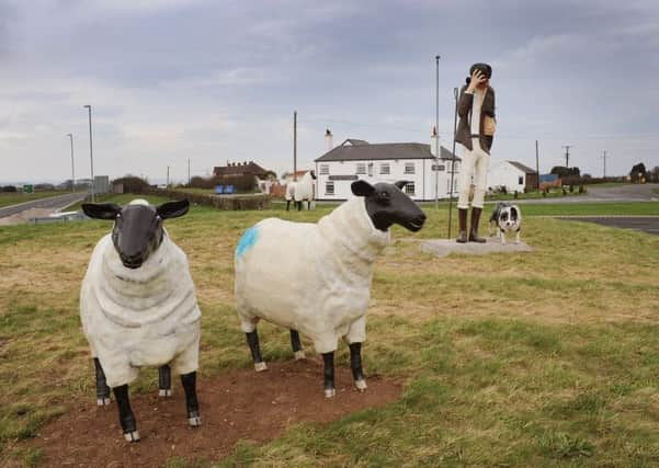
Hide AdYour route maintains its course beside Reighton Field, now returning north towards a road junction. Do admire the unusual roundabout. It bears a sculpture of a tall, slim shepherd with most realistic sheep, which even attracted our dog’s attention. At this traffic island, turn left along Hunmanby Road, and left again, to access the car park and, entrance to Reighton Nurseries. Do take time to view the extensive nurseries which are highly popular for quality and price.
Next – leaving the car park, turn left along Hunmanby Road. Reaching crossroads, turn right beneath the road bridge to find yourself on St Helen’s Road once more. Keep well in to the verge, as there’s no footpath as you return to Reighton village and your departure point. A bus stop is just to your left, should you require one.
Now, with energies renewed, how about taking Sands Road (seen on the map), to Reighton Gap? Enjoy your day.
Distance of circular route: Almost four miles, easy walking.
Advertisement
Hide AdAdvertisement
Hide AdRefreshment: Reighton Nurseries (open seven days a week from 9am-5.30pm). Toilets: Nurseries.
Also, The Dotterel Inn (near the shepherd and sheep roundabout).
Transport: Private or bus 121 and X21 to Bridlington etc.
Map reference: Ordnance Survey Explorer 301. Scarborough, Bridlington and Flamborough Head. Scale: 2.15 inches to 1 mile.